")


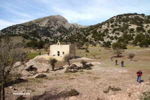
At the east sides of the volcano-like peak of Strouboulas (seen from Heraklion), you will meet the small plateau of Strouboulas. It is a typical limestone plateau with limited vegetation due to overgrazing, but it hides wild beauty. At one side, you will meet the chapel of Saint George and at its lowest place, a small pond is formed in the winter. This small unknown wetland is highly dependant on the rainfalls. The water is reddish due to the grounds that remind of African landscapes.


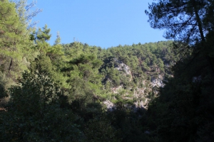
The lush canyon of Vederi starts from the village Fratzeskiana Metohia, passes next to the village Vederi and ends on the beach of Gerani (after 7km). The canyon has dense vegetation that makes trekking very difficult, as there is no footpath along its length.


The cave is located north- east of the village Nithavris at an altitude of 700m. at position Kalikas. Its dimensions are 100m x 40m and has a maximum height of 20 meters. Apart from its many names (Onymahos, Kallika Trypa, Notiki Tripa Nithavris, Paul Faure Cave), the impressive entrance with the inscription with the ancient name ONYMAXOC, it hosts beautiful stalactites and hides a rich history that testifies that it was inhabited since ancient times.

The canyon of Prasses or Askidia is located in a wooded area of the White Mountains. Its exit is located near the village Askidia (altitude 480m), which is a part of the village Prasses, hence the two names. To find the starting point of the canyon you have to drive on the road that heads from Chania to Sougia and turn at the intersection of Petras Seli leading to Omalos Plateau.

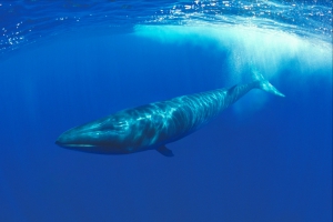
The fin whale (scient. Balaenoptera physalus), finback whale, razorback, or common rorqual is the second largest mammal in the world, after the blue whale. In Greece there are fin whales, some of which have been observed occasionally in the deep waters of south Crete. The number of fin whales in the Greek waters has not been estimated, but it is estimated at 2000 individuals throughout the Mediterranean.

West of Skinokapsala village, at position Kipos, starts the small and quite quite wide gorge of Ahlia. The pine-wooded gorge finishes at the beach of Ahlia, known as Galini. During the winter months, waters from Thripti Range form a river along which there are several waterfalls (ranging from 5 to 8 meters high). Because the sandstone walls are not narrow, hiking is quite easy and no canyoning equipment is needed.

At the coast between Panagia Charakiani and the hill Kefali, with the archeological findings, a bit west of Holy 318 Fathers, we meet the area of Propatoumenos. Propatoumenos means the area that can be walked, as there was a trail to the nearby ancient town of Astali, by Bali.

The Plateau of Lapathos is located about 77km southeast of Heraklion and 36km west of Ierapetra, near Kato Symi village. It is a small but beautiful plateau. The background of the plateau is the wild beauty of the Lasithi mountains and the slopes of Selakano. The vegetation in the Plateau is not dense and there are many rocky places.
Also read:

- Home
 Beaches
 Nature
 Past
Past Destinations
 Highlights
 West Crete
- Central Crete
- East Crete
- Towns
- Chania Prefecture
- Chania
- Paleochora
- Kissamos
- Georgioupolis
- Chora Sfakion
- Loutro
- Rethymnon Prefecture
- Rethymnon
- Agia Galini
- Plakias
- Spili
- Anogia
- Heraklion Prefecture
- Heraklion
- Hersonissos
- Malia
- Matala
- Agia Pelagia`
- Archanes
- Kokkinos Pirgos
- Lassithi Prefecture
- Agios Nikolaos
- Elounda
- Sitia
- Ierapetra
- Makrigialos
- Palekastro
- Zakros
- Lassithi Plateau
- Get Prepared


