")


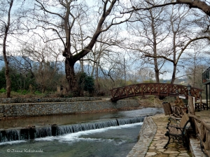
The Boutakas River is located in the province of Apokoronas in Chania, which originates from the White Mountains near Vafes village. It passes through the village of Vrysses, where there are many beautiful taverns, and flows into the beautiful beach of Kalyvaki in Georgioupolis, after being mixed with salt water.

On the southeast side of Afendis Christos summit, above the villages Embaros you will meet the verdant vineyards at Erganos plateau at 900 meters altitude. The water gathered from the melting snow of the surrounding slopes and from many springs of the region form the main tributary of the Anapodaris river, Baritis, which crosses the plateau of Erganos and forms the rugged canyon of Erganos.

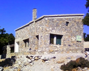
The mountain shelter at position Samari is located at an altitude of 1417 meters on the west side of the gorge of Agios Nikolaos. It's a single-room stone building with a wooden attic that can accommodate up to 20 climbers. It has 2 W.C., fireplace and there is a possibility for cooking. There is water available from a cistern which is not potable.

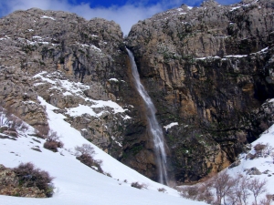
Above Krya Vryssi we meet one of the highest waterfalls in Crete, the waterfall of the wild gorge Gre Daphne, known as Rechtas. It has water until spring and falls from a height of 100m! A little further down, in the ravine of Gre Daphne, there is the rock climbing field of Krya Vryssi.
The gorge of Mindris starts near the village Filippi and ends at the port of Tsoutsouras, after running a distance of 6km. It is a open canyon without vertical walls, which’s riverbed is dry in summer and very easy to walk. On the riverside traces of ancient settlements, ranging from the Minoan to Roman Era have been found.

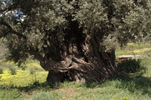
Paliamas Olive Tree has been declared monumental by the Association of Cretan Olive Municipalities due to its relief trunk and size. This olive tree dates back to the Sub-Minoan First Geometric period, produces big olives and it’s got a big cavity in its trunk, where three people can fit in. Its perimeter at its foot measures 20.40 meters and at a height of 80 cm from the ground it measures 10.50 meters.
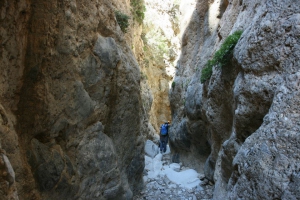
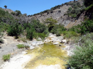
Anapodaris Gorge is formed at the final part of the longest river of Crete, Anapodaris, that collects the waters of Central Province Heraklion and South Dikti Range. The suggested route has a duration of 3-3.5 hours and is possible during summer or late spring when the river does not have too much water. It is worth noting that the river empties to the sea about 40 million cubic meters of water annually.

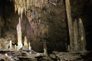
The Cave Dadoulas or Maxime is an underground river at Dadoulas area by Vrysidi settlement. It has a total routes’ length of 760m, depth of 260m and ends at a siphon (well). It has very rich decor and is characterized as a "living museum of the geological history” of the region.
Also read:

- Home
 Beaches
 Nature
 Past
Past Destinations
 Highlights
 West Crete
- Central Crete
- East Crete
- Towns
- Chania Prefecture
- Chania
- Paleochora
- Kissamos
- Georgioupolis
- Chora Sfakion
- Loutro
- Rethymnon Prefecture
- Rethymnon
- Agia Galini
- Plakias
- Spili
- Anogia
- Heraklion Prefecture
- Heraklion
- Hersonissos
- Malia
- Matala
- Agia Pelagia`
- Archanes
- Kokkinos Pirgos
- Lassithi Prefecture
- Agios Nikolaos
- Elounda
- Sitia
- Ierapetra
- Makrigialos
- Palekastro
- Zakros
- Lassithi Plateau
- Get Prepared


