")


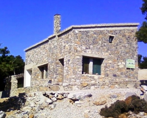
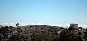
The mountain shelter at position Samari is located at an altitude of 1417 meters on the west side of the gorge of Agios Nikolaos. It's a single-room stone building with a wooden attic that can accommodate up to 20 climbers. It has 2 W.C., fireplace and there is a possibility for cooking. There is water available from a cistern which is not potable.

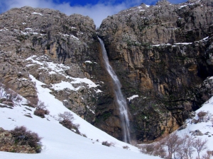
Above Krya Vryssi we meet one of the highest waterfalls in Crete, the waterfall of the wild gorge Gre Daphne, known as Rechtas. It has water until spring and falls from a height of 100m! A little further down, in the ravine of Gre Daphne, there is the rock climbing field of Krya Vryssi.

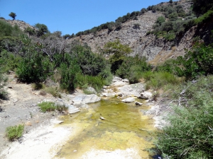
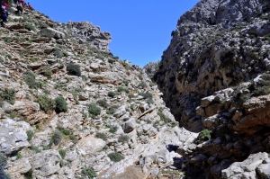
The gorge of Mindris starts near the village Filippi and ends at the port of Tsoutsouras, after running a distance of 6km. It is a open canyon without vertical walls, which’s riverbed is dry in summer and very easy to walk. On the riverside traces of ancient settlements, ranging from the Minoan to Roman Era have been found.
Anapodaris Gorge is formed at the final part of the longest river of Crete, Anapodaris, that collects the waters of Central Province Heraklion and South Dikti Range. The suggested route has a duration of 3-3.5 hours and is possible during summer or late spring when the river does not have too much water. It is worth noting that the river empties to the sea about 40 million cubic meters of water annually.

The plateaus of Tavri and Niatos are located 2km and 3km west of Askifou Plateau, 51km south of Chania, at an altitude of 1200m. They can be accessed via a road starting from Askifou, crossing Tavri and then ending up in Niato.

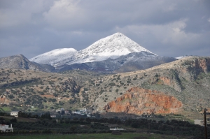
Strouboulas is the first peak that one can see from Heraklion when looking to the west. The height of the tops is 798 meters above sea level, a small altitude compared to the surrounding mountains and the range of Psiloritis it actually belongs. What makes Strouboulas special and beloved by the locals is its shape reminiscent of the pyramid or volcano when looking from Heraklion. In fact, however, its shape is elongated from east to west but from the city it looks like a perfect pyramid.

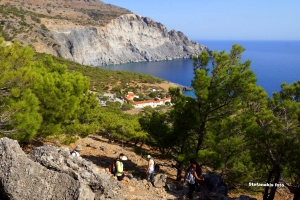
The monastery of Koudoumas is located 74km south of Heraklion, on the western side of Cape Martelos and south of Kofinas Peak (the highest peak of Asterousia Mountains). The whole area is full of cavities where hermits used to live. To reach the monastery, you have to drive in a passable dirt road of 20km, starting from the village Sternes, which descends from an altitude of 1000m to the sea level. The views during the descent are shocking and could cause vertigo! The route passes between pine and cypress trees, many of which are bent by the wind..
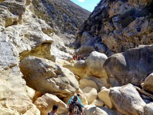
The Gorge of Ethia, officially known as Vorno, is located south of Heraklion, at the Asterousia Range. It starts from the village Ethia and, after tearing Asterousia northwards, it finishes at the plain of Messara, between the villages and Rotasi and Mesochori.
Also read:
- Home
 Beaches
 Nature
 Past
Past Destinations
 Highlights
 West Crete
- Central Crete
- East Crete
- Towns
- Chania Prefecture
- Chania
- Paleochora
- Kissamos
- Georgioupolis
- Chora Sfakion
- Loutro
- Rethymnon Prefecture
- Rethymnon
- Agia Galini
- Plakias
- Spili
- Anogia
- Heraklion Prefecture
- Heraklion
- Hersonissos
- Malia
- Matala
- Agia Pelagia`
- Archanes
- Kokkinos Pirgos
- Lassithi Prefecture
- Agios Nikolaos
- Elounda
- Sitia
- Ierapetra
- Makrigialos
- Palekastro
- Zakros
- Lassithi Plateau
- Get Prepared


