")


The first beach of Xerokambos (on the west) is the harbor of Amatos. A natural harbor with calm waters is formed there with several boats. The remote beach is pebbly and is ideal for fishing. There are 2-3 tamarisk trees and a ramp for launching boats. The road leading to the harbor from the settlement of Xerokambos is an accessible dirt road. From here starts the path to the beach of Agia Irini.
If you walk 1 hour east of Vlyhada beach at Livari (by Goudouras), you will soon reach the two deserted beaches of Tihida area. The area is full of caves and takes its name after the wall-like rocks (tihos in Greek) at the small beach, offering shade during summer.
The longest beach at Koufonissi lies in the southeast part of the islet, overlooking Africa! Amazing clean water, rocky seabed ideal for snorkeling, and smooth sand ideal for playing beach tennis. The only problem is the lack of shade.
Kapsas Monastery is located 37km southwest of Sitia and 32km east of Ierapetra, between Makrigialos and Goudouras. It is a very old monastery built on the cliffs near the exit of the arid Pervolakia Gorge. To get here you can follow the paved road that links Makrigialos to Goudouras, but there are also (rare) bus services from Ierapetra.

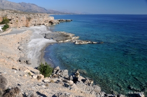
Psalidia means scissors in Greek and this name is taken after the shape of the bay. The surrounding area is very dry and is cover by low sand dunes and shrubs, but in September it turns to a paradise by thousands of white sand lilies. Moreover, if you walk to Lagada, you’ll meet many amazing rocks that are ideal for shooting photos.
If you head 1km to the east of Myrtos you will meet the long beach of Sarikambos, that is more secluded, but the seabed becomes coarser. 2 more km on the east, you'll find a small bay next to the greenhouses of Nea Myrtos settlement. This is avoided for swimming due to the greenhouses that might pollute the water.

In the area between Ravdoucha and Nopigia several secluded bays with small beaches are formed, mainly with pebbles and rocky bottom. From Nopigia the road runs along the coast through a spectacular seascape till the church of Panagia Myrtidiotissa at position Choni and stops a little further.

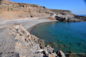
The small pebble beach Vourlidia is formed at the exit of Flomias gorge, at the west part of Salamias bay and at the base of Oxa cape. This incredible beach can be accessed after strenuous hiking from Agios Ioannis (east) or Tripiti beach (west). The place above the beach can be approached through very bad dirt track from Koumasa or Kapetaniana.
On the E4 European trail that connects Sougia and Paleochora we meet the astonishing tiny beach of Astropelekita. We meet this beach to the east of Plaka stony cape and before starting ascending to Flomos Cape for reaching Lissos. This cove is a great chance to have a cooling bath while hiking the E4 trail.
The beach that stands out from all of the west side of Gavdos is Diana. Diana is actually the second southernmost beach in Europe, after Tripiti which is located a few meters to the southeast. The beach stands out from the rest as it is less rocky, has small pebbles and has a massive rock below which you can find shade all day.
The beach Keratidi, or to be more accurate the two beaches of Keratidi, are located at a secluded location east of Laki, province Sfakia, and are actually the easternmost beach of south Chania prefecture.
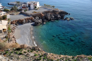
Helidoni or Porto Helidoni beach starts immediately after the south side Paliokastro and is under new highway. A staircase with wooden steps leads down to the sea level. What is striking is the cleanliness of the beach and water clarity reminiscent of the best beaches of southern Crete. The beach has easterly direction and, therefore, it almost always calm, like all beaches from Ellinoperamata to Theseus. It is a tiny beach with fine pebbles and sand in some places.
On the island there are several small beaches, the largest of which is located north of the site is sandy. Just below the ancient settlement (to the south) there is a small bay with two small beautiful pebble beaches. All beaches of Pseira are located on the south side of the island thus they are protected from ordinary north winds.
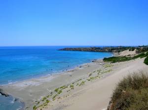
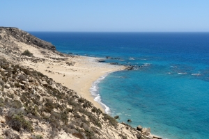
Orthi Ammos is one spectacular sandy and shallow beach, next to Frangokastelo, located 80km south of Chania, at the edge of a big valley with very warm climate. The area is not overdeveloped, in contrary to the touristic area of Frangokastelo.
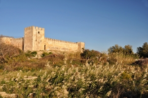
Fragokastelo (ie the castle of the Franks) is one of the most famous beaches of Crete, famous for the local Venetian castle on the beautiful beach and the legendary ghosts of Drosoulites. It is located 13km east of Hora Sfakion, 80km southeast of Chania, in a small valley south of the White Mountains.
Vatalos is located 80km southeast of Chania, 1.5km west of Fragokastelo beach. Most of Fragokastelo hotels and rooms to let are located in the area of Vatalos, which is a flat area with fertile fileds and amazing views to the south slopes of White Mountains.
Koutelos is a calm, unorganized beach with large round pebbles, near the village Nomikiana. It is located about 9km east of Chora Sfakion, 4km west of Fragokastelo and 76km south of Chania.
Beach Filaki (meaning "Prison") is located 3km east of Chora Sfakia and 75km south of Chania. Located close to the only hotel exclusively for nudists in Crete, called "Vritomartis, Filaki and the adjacent beaches of Ammoudi are mainly occupied by nudists.
The cove of Agios Charalambos is located next to the hotel of Vritomartis exclusively for nudists. They are located 1.5km east of Chora Sfakion and 75km south of Chania, in an area with several adjacent pebbly beaches.
Chora Sfakíon or Sfakia is a small town on the south coast of Chania. It is the capital of the remote and mountainous region of Sfakia, and is a small town of just 278 inhabitants (2001 census). It lies on the south coast near the end of the Imbros Gorge, 74km south of Chania.
Also read:
- Home
 Beaches
 Nature
 Past
Past Destinations
 Highlights
 West Crete
- Central Crete
- East Crete
- Towns
- Chania Prefecture
- Chania
- Paleochora
- Kissamos
- Georgioupolis
- Chora Sfakion
- Loutro
- Rethymnon Prefecture
- Rethymnon
- Agia Galini
- Plakias
- Spili
- Anogia
- Heraklion Prefecture
- Heraklion
- Hersonissos
- Malia
- Matala
- Agia Pelagia`
- Archanes
- Kokkinos Pirgos
- Lassithi Prefecture
- Agios Nikolaos
- Elounda
- Sitia
- Ierapetra
- Makrigialos
- Palekastro
- Zakros
- Lassithi Plateau
- Get Prepared


